
The Infamous Suchetha Colombo Tour
I love Colombo. I love the nightlife. I love the daylife. I love the food, the beaches, the expensive places, and the dive-ass bars. I love it all, and I love showing it off to my friends.
Once upon a time a friend came down, and wanted to see the place, so I took them to places I knew and loved. Then another came, and another, and now I have a whole fucking itinerary *glee*.
So, because people I have never met keep asking me what to do (and because my memory is failing due to horrifying abuse), let’s write this down.
Please note, that this tour, and everything I say here is coloured heavily with my own experiences and biases. There will always be someone who will disagree with me, often vehemently, occasionally violently.
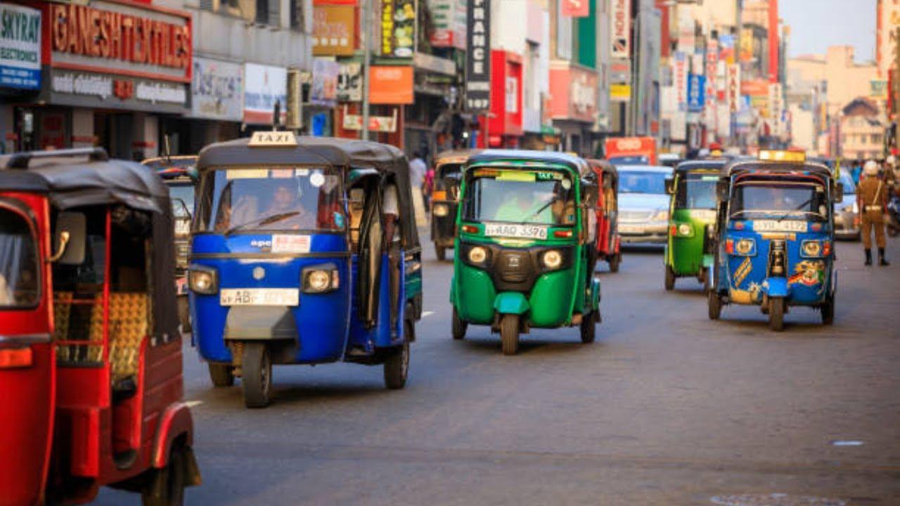
This run is done best via trishaw (tuk-tuk to you non-Lankans) and foot. Wear comfortable shoes, keep your valuables safe, and try to enjoy the ride. I will try to avoid backtracking as much as possible, but it happens.
How long it all takes depends on how much time you want to spend, and when you start.
I am trying to break this guide into sections and subsections, so that when we stop at one location, there are a few places you can walk to in the vicinity. There are transit locations you can get see from the road, but are not really worth getting down for.
This will be a living document, where I add things as we go along, so check the last edit date at the bottom to see how accurate it is.
So, are you ready? Let’s begin! Allons-y!
Galle Face Area
Galle Face #Wikipedia #Map
Ah, the Galle Face Green (not at brown as it used to be). The meeting spot for many inner-city families, because it is one of the few publicly accessible green locations around. There are a few canons still left on the Green, so keep a look out for the famous “umbrella lovers”.
Galle Face Green is now less than half of what it used to be. It used be a horse racing track, with a part of the Taj Samudra Hotel at its centre. It has been carved up by the Galle Road (A2) and cut up for hotels and development. But it’s a good place to be, and sunsets here are usually fun. Swing by in the evening, eat the food - it’s tasty, and well worth the price you pay the next morning.
The Galle Face Hotel #Wikipedia #Map
I mean, what can I say? It’s right there and more has been written about it than I could. It’s the oldest hotel in Sri Lanka, and has a serious colonial groove going on. Go inside and explore. There’s lots to see. Go to the Verandah, and take some Insta-worthy shots of the sea and the lawn.
Galle Face Court 2 #Map
Across the road from the Galle Face Hotel, is the Galle Face Court 2. Built in 1923, it was supposedly Sri Lanka’s first apartment complex. Built in the 1923, it still has apartments, and in the old style, a row of shops on the ground floor. You can’t tour the inside, but the outside is pretty impressive.
Trishaw time! Get in the trishaw, head North. As you go by, you’ll see Galle Face Green on the left, and The Taj Samudra Hotel on the right. Just past the main hotel building, is the Colombo Club #Wikipedia #Map, Sri Lanka’s oldest and most exclusive club. So exclusive, they allowed their first female member in 1995.
Further down the road, you’ll see the Old Parliament Building #Wikipedia #Map. Built in 1930, it served as the Parliament of Ceylon and later, Sri Lanka until 1983. That year the Parliament was moved to its own complex, and this building became the office of the Presidential Secretariat.
On the left is Port City #Wikipedia #Map the giant construction sea reclamation and city-building project being done by the Chinese Government.
At the roundabout go to Chaithya Road. Our destination is the Colombo Galbokka Lighthouse #Wikipedia #Map. It used to be a great vantage point, but no longer, thanks to all the construction. Even the lighthouse has been decommissioned. So why are we here?
Facing the sea, on your left is the now-nonexistent Gal Bokka or rock bay that gave this area its name. The British Anglicised it to “Galle Buck” naming the nearby Galle Buck Road for it. The rock bay was also home for a natural swimming pool that has now disappeared under the Port City. On your right is the Sambodhi Temple #Wikipedia #Map
Back to the trishaw! Tell the driver you’re going to the Dutch Hospital #Wikipedia #Map, and ask him to park there and wait for you. But ask him to let you out at the Ceylinco Building #Map. Welcome to our next major stop, welcome to the Colombo Fort #Wikipedia #Map
Colombo Fort #Wikipedia #Map
Colombo Fort is the oldest part of Colombo, being built in the 1500s by the Portuguese, then upgraded by the Dutch, and then upgraded and finally torn down to make room for development by the British. It was the administrative heart of Ceylon and Sri Lanka until 1983, but still remains the commercial (and some would say social) heart of Sri Lanka. It is crowded (watch your bags and pockets) and polluted and chaotic and insane and I fucking love it!
Most of what we are looking at and for will be in Fort and its outskirts Pettah #Wikipedia #Map. Pettah is an Anglicisation of the Sinhalese word pita (outside) which is a shortening of pita-kotuwa (“outside the fort”). If you’re into Latin and Roman forts you could call it a vicus.
Now that you have an idea of where we are, let’s explore. Time to walk!
King Sri Vickrama Rajasingha’s Cell #Map
Sri Vickrama Rajasingha was the last king of Lanka. In 1815, he was captured in Kandy by the perfidious British who held him in a tiny cell, before he was transported to Vellore, where he died. The tiny cell he was held in can be seen in the parking lot of the Ceylinco Tower. Or that is what we are taught in school. The tale of the tragic king, and the evil British.
The truth is, as always, more complicated. Rajasingha was a Telugu Tamil boi from Madurai, and that just didn’t sit well with the Sinhala nobility of Kandy. So some of them rebelled. And the King - as was normal for the time - killed off one of the leader’s family in rather gruesome ways. This led to the rebels going to the British and denouncing Rajasingha as a despotic ruler and giving them causus belli to invade Kandy in force and capture the king. The rebels were expecting the British to hand of the kingdom to them, which - surprise, surprise - they didn’t. *shocked Pikachu face*
Rajasingha was captured, and he was brought to Colombo and held in this area. But not in this cell! There is ample proof that this was a much later construction, and that there is no way the King could have been held here.
Dutch Hospital Shopping Precinct #Wikipedia #Map
This is probably one of the oldest buildings in Colombo. It started off in the 16th century as a hospital, then went through many roles (including as an Army post during the Civil War) to become what it is now - a shopping and entertainment district. It’s a beautiful example of old Dutch architecture, and full of Insta-worthy locations.There are a lot of tourist-oriented shops here, and it’s well worth a long stop if you have the time. But don’t buy anything you don’t intend to carry with you for the rest of the tour.
Go out the back of the Dutch Hospital, turn left, and then follow the road until you get to Chatham Street #Map. On Chatham Street, turn left.
The Old Colombo Lighthouse Clock Tower #Wikipedia #Map
This clock-tower lighthouse was built in 1856 and deactivated in 1952. It is the point of origin of the road measurements of Colombo. When you hear that Colombo to Location X is Y kilometres, this is where 0 is.
Green Cabin, Chatham Street #Map
Green Cabin is a bakers. They serve pretty decent pastries and savouries (what Sri Lankans call “short eats, and an acceptable lamprais (more on that later). But this location is also interesting as it was one of the shooting locations of the music video for Duran Duran’s Hungry Like the Wolf. The interior hasn’t changed that much, but there are no snake or monkey charmers.
Get to the main road, get the trishaw to meet you, time to ride
We’ll drive down York Street, and then N H M Abdul Cader Road (it used to be called Reclamation Road, because it was built on land reclaimed from the sea). As you go by, on the left side you can see old colonial commercial buildings, many of which have fallen into disuse and disrepair. But they look pretty cool (from the outside at least) and are well worth slowing down to take a look at.
As you go down N H M Abdul Cader Road, you’ll see a clock tower (another!) on a roundabout, and the walls and gate of the Colombo Harbour on your left. We go down the road, and on your right is the BangBang Building #Map, Sri Lanka’s first shopping mall, and a place to visit if you’re into urban decay porn.
A little further, and on the left is the next destination.
St Anthony’s Shrine, Kochchikade #Wikipedia #Map
This shrine-turned church is one of the oldest in Sri Lanka. It’s nice, has an interesting feel to it, but its (unfortunate) claim to fame is that it was one of the targets of the [2019 Easter Bombings]. They still maintain some of the sections in its damaged state as a memorial to the tragedy.
Back on the trishaw, we’re going to Wolvendaal Down Jampettah Street, and up Vivekananda Hill we go, keep an eye out for some old-style buildings as we go past. People still live there, so please be respectful. All the we up and we reach our next destination.
Wolvendaal Dutch Reformed Church #Wikipedia #Map
This is one of my favourite destinations, because it has so much social history in there, if you know what to look for. Wolvendaal Hill (named for the jackals that used to be seen there in the olden days - wolf’s dale), is one of the highest points of the city, and even now commands quite a view, despite the proliferation of multi-story buildings around it. The church itself is old, venerable, and impressive. It also smells slightly of bats. The church has absolutely massive walls made up of kabok (a clay stone with a high iron content) and coral cement. Those walls are solid. There are old gravestones here signifying the many people who lived and died in the country. It’s almost possible to imagine life here for them. You can show up, and (if they’re open) take a look around. Be nice, and leave a donation. Once you have seen the inside and the church grounds, come out on to the road.
Go to the main gate, and imagine walking out of there on a bright Sunday, after a long service in a dark and gloomy church. You walk out, and as your eyes adjust to the light you see the city below you and the blue sea beyond. It still looks impressive now, it must have been awesome then. As you look down the road to the sea (it’s an almost direct line), you will see the spire of the Buddha Jayanthi temple - the temple-on-stilts.
Wolvendaal Church was built on the highest point outside the Fort. It also became the first thing that sailors would see as they sailed into the harbour. It remained so until 1957, when, to commemorate 2.500 years of the Buddha attaining Enlightenment (probably, the dates are iffy) the Government decided to build a temple closer to the harbour, and also make it higher and more visible than Wolvendaal Church, because religions gotta religion, I guess.
Back to the trishaw! And away we go! Down Central Street, to the Five Lamp Junction (probably called that because five streets meet here), and on to the Main Street Junction. Hop out here, because from here, we’re going to be walking. Not far, just 1.5km (about a mile for those of you unfamiliar with the metric system). This is the heart of Pettah, Colombo’s original and current commercial district.And away we go! Down Central Street, to the Five Lamp Junction (probably called that because five streets meet here), and on to the Main Street Junction. Hop out here, because from here, we’re going to be walking. Not far, just 1.5km (about a mile for those of you unfamiliar with the metric system). This is the heart of Pettah, Colombo’s original and current commercial district. Again, a reminder to watch your bags and pockets. Lots of tourists come through here, and they’re a favoured target.
Anyway, we step out here at the …
Old Town Hall Building #Map
You can’t miss it. It looks weird and quite out of place in its surroundings of modern buildings. And there’s usually a fire engine parked outside. But there it is. Built in 1873, this was the Colombo Municipality headquarters for over 50 years, until they moved to the New Town Hall. If the doors are open (and they often are) you can walk in, and see if you can find someone to guide you around the place. There’s a museum of old Colombo Municipality equipment in a gorgeous wrought iron building next door, that’s well worth a visit. It’s still (kind of) in use, and there’s lots of interesting stuff to see. Trust me on this, no spoilers.
Old Town Hall Market (Edinburgh Hall) #Map
Head out of the Town Hall, turn right, go around the corner, and walk for a bit and you’ll come across the entrance to the Town Hall Market. Look up and you’ll see filigree wrought-iron columns and structures and imagine what it would have been in its heyday when it was the Edinburgh Hall, a centre for the arts in the area, It kind of reminds me of Covent Garden, with a similar architecture, and built about the same time.
Kayman’s Gate Dutch Bell Tower #Wikipedia #Map
Backtrack a bit, go past the Old Town Hall, and at the corner of Main Street and 4th Cross Street, you’ll find the Kayman’s Gate Bell Tower. Named for the crocodiles (“caaimans” in Dutch) who lived in the lake, this is one of the remnants of the old Dutch fort, being the main entrance to the Eastern ramparts. Up until the late 19th century, this area was also used for public hangings.
The Red Mosque (Jami Ul-Alfar Mosque) #Wikipedia #Map
Walk a bit further, and on the far side of the street you’ll see the Red Mosque - officially the Jami Ul-Alfar Masjid, one of the most gorgeous buildings in Colombo. The mosque, with its red and white colouring is quite distinctive, and makes for some great shots. Built in 1909, it’s really not that old, but just look at that!! If you have time, you can enter it and take a look around, or you can keep walking.
Top Tip Go to the Bombay Sweet House next to the mosque, and get yourself a beef samosa or three. They’re crispy, greasy, and a personal favourite. Pretty much every other place sells chicken samosa, and you can’t find a decent mutton samosa for love or money.
Walk a little way forward, and you’ll cross Keyzer Street, and then find 2nd Cross Street. Turn in, walk up to the intersection with Prince Street, and walk to the right. Just a little way down and you will see the façade of the …
Dutch Museum #Wikipedia #Map
This building was probably built in the late 1600s, and then was used by the Dutch governor of the time as his formal residence during his term of office in the late 1600s. It has been a teacher training college, orphanage, barracks, hospital, police training centre, and post office. It was almost destroyed in the 1970s and restored to a museum in 1982. It has a huge collection of old Dutch furniture, household effects, gravestones, and other memorabilia. Definitely worth a look. Walk on to the far end of Prince Street, where it meets Front Street/Malwatta (“flower park”) Road, then turn left. This will bring you to the hustle and bustle of Olcott Mawatha, right across the road from the Fort Railway Station. Turn right, take the pedestrian bridge across the road, and there you are.
Fort Railway Station #Wikipedia #Map
I mean, what’s there to be said? It’s a railway station. It’s large, and it has some great shots if you want to take travel-porn. It’s where you come to to take trains out of Colombo (have you done the Colombo-Kandy-Ella run yet?).
Walk to the right (have the traffic on your right), and you’ll pass the commercial glory that is the Pettah World Market. There’s lots of stuff you never needed, and never knew you wanted for sale there. And the shop-owners are the masters of the upsell, downsell, oversell, undersell, and will sell you everything you thought they could never sell you. Walk quickly, try not to give in to temptation.
Just past the World Market is a bridge (*ooh, the smell!*), and just past the bridge is a flight of steps heading down to a beautiful walking path next to the horrifyingly polluted waters.
Beira Lake Walk #Map
It’s just a nice walk, if you try to ignore the smell (don’t worry, your nose will give up the ghost sooner rather than later). Shady trees, nice view, pelicans, people relaxing watching the pelicans. It really is quite nice.
Go all the way down and you’ll come up next to the Lake House #Map, home of the Associated Newspapers of Ceylon, Ltd #Wikipedia, the government mouthpiece newspaper.
Cross the road - do it Sri Lankan style, wait for a break in traffic and run - and you’ll come to the end of the walking section of this tour …
McCallum Lock Gates #Wikipedia
Built in 1958, the McCallum Locks were to help facilitate water-borne traffic between the harbour and the then barely-functioning canal-based transportation system. The canals are no longer in use, the locks are in disuse, and all they do is help keep the water in the Beira Lake. There is a park there, and you can look out into the Beira. Sometimes, you may even see rowers from the Colombo Rowing Club #Wikipedia
Trishaw time! Hopefully your trishaw driver is cool, and knows what you’re doing. Hopefully he’s waiting for you. Get in, head down the A4, past the various hotels and everything until you get to …
Outer Colombo
Hotel Nippon #Map
It’s not historical, but it’s old, and I do like dropping in there for a drink or three. But slow down, admire the look, and if you’re peckish, step by the café, and get yourself some mutton and beef rolls. They are easily some of the best in town.
Beira Lake #Wikipedia #Map
The Beira Lake is actually a multitude of pieces. In the olden days Colombo was a marsh, and was drained and filled to make it what you see today. This smaller Beira Lake (what most people think of when you say the name) is better known and noticed than the larger part. It is severely polluted and stinks to high heaven, and many governments have promised to clean it up, but the Beira remains. The island in the centre is a children’s park, but not really worth visiting.
Gangarama Temple #Wikipedia #Map
Gangaramaya Temple, you will never find a more wretched hive of scum and villainy. Well, actually, you probably can, but this temple is on the top end of the list. I wouldn’t say “don’t go see it,” because it is nice, and has lots of interesting stuff (like the chief priest’s collection of antique vehicles), but it is a tourist trap. You can go in, and take a look around, and there will be a priest who will offer to bless you and tie a thread around your wrist, and then give a significant look at the donation box. My personal advice; stop, take some photos of this and of the Seemamalakaya #Wikipedia #Map on the lake, and move on.
Town Hall #Wikipedia #Map
You have seen the Old Town Hall, and now this is the Town Hall. It looks very impressive, and suspiciously like the US Capitol Building, but it has been around for a long time (since 1928) and looks quite impressive. You can stop for a bit in front of it, and take some pictures, though there are no tours of the interior.
And across the road from the building is the…
Vihara Maha Devi Park #Wikipedia #Map
It started off as the Victoria Park and after independence was renamed for the mother of one of the great kings of Lanka. It’s large, beautiful, and is great to take a walk in. But we’re not going to, because there is one last thing to see.
Colombo National Museum #Wikipedia #Map
The Colombo National Museum looks great on the outside, and has a pretty good collection inside. But if you’re used to other, more international museums, it feels sorely lacking. It’s a good place to spend a few hours, but we’re not going to, because we’re driving by.
And that’s it. This is my standard tour of Colombo I subject my friends to. I sometimes add things if they’re interested, and subtract things if they’re not, but this is a gallery of the usual suspects.
I hope you had a good time, please let me know what you think of this.
The End … or is it?
Over? Did you say “over”? Nothing is over ’til we decide it is!
If my timing is right, it should be about 1pm by now. Maybe later, but either way, it’s time for lunch.
Dutch Burgher Union #Wikipedia #Map
This is my first-choice when I take my friends out. Lamprais and Lion at the DBU. The DBU was started by the descendants of the Dutch colonists who intermarried with the Ceylonese, and lived their life in the country. It’s a very nice turn-of-the-19th-century building in the heart of Bambalapitiya. Lamprais is a dish the Dutch picked up in Indonesia and dropped in Ceylon, forgetting to take it back to the Netherlands. Their loss, our gain. A small, succulent lump of savoury rice and sides, packed in a banana leaf and baked, a well-made lamprais will blow your mind. There are lots of places that make lamprais, but the DBU makes it in the original style that you can’t find too often. Pair that with a Lion beer (Sri Lanka’s local beer, and hopefully they haven’t fucked up the process this brew), and you have the perfect post tour meal. Eat, drink, sit in the shade and talk about the run, figure out what you want to see for longer; the DBU courtyard is perfect for that.
Just remember, the lamprais sell out, so call them up (the Google map link has the number) and make sure they have them in stock.
Barefoot Gallery and Café #Wikipedia #Map
Barefoot is a Colombo institution. It’s a handloom clothing shop, a bookshop, an art gallery, and a café, but it’s also a place where you can come and hang out, and meet people. I have spent many days working on my laptop there with a beer or three to keep me company. If there’s no lamprais at the DBU, I bring my friends here. But even if there is lamprais, I would swing by here with them anyway. It’s that kind of place.
Yaarl Eat House #Map
Feeling brave? Ready to eat with your fingers, blow out your tastebuds, and put your rectal sphincter at serious risk tomorrow? Let’s head over to the Yaarl Eat House on Wellawatte Station Road. It’s a tiny little hole in the wall, and may well scare you. But it’s clean enough, and the Jaffna crab curry (what we came here for) is off the charts. It’s spicy, tangy, and is as good or - dare I say - better than any crab I have had in Jaffna. Also, if you look around, you will notice there are no foreigners here, just locals, and not just any locals, but people from the vicinity
The place is so good, there are copycats with similar names in the area, so make sure you get the spelling and the wording right.
And it’s late afternoon, getting on evening, so it’s time to indulge in that great Colonial/Island tradition - sundowners. Pick up some alcohol of your preference (my choices are Lion lager, V&A London Dry Gin, and Rockland Dark Rum), because the places we are going to are BYO, and head to one of these two places. They both have swimmable beaches, but remember, the water is rough, and there are no lifeguards. Please be careful. (And needless to say, swimming after alcohol is extra dangerous)
Pink Salt #Map
On the beach in Dehiwala, across the railway lines, there is a plethora of restaurants. I have been to far too many of them, and Pink Salt is one of my favourites. Get a table near the gate to the beach (the others are shielded by trees), and you can watch the sun go down with a drink in your hand. Pink Salt does excellent Hot Butter Cuttlefish (a Sri Lankan creation that is just perfect accompaniment to a drink), and their prawn balls and prawn toast are excellent.
Golden Beach Lavinia #Map
A few kilometres further down, on the Mount Lavinia beach is the Golden Beach Lavinia. It may be better for sunset watching because the view of the beach and sea is uninterrupted. And since it is completely roofed over (Pink Salt is mostly open to the sky) you are protected from sudden showers. Their HBC is very good, and they make some excellent spicy finger food (what we call “bites”) to accompany your drink.
There you go, a whole day done. Drink the sun down, and you may even make new friends (Sri Lankans get very friendly when the alcohol starts to flow).
Have a great time.
Add new comment